


22 secs ago
7,927
Author: Shayon Sengupta, Multicoin Capital; Compilation: 0xjs@Golden Finance
Today, we are excited to announce that Multicoin has taken the lead in strategic acquisition of Geodnet Networks from the Geodnet Foundation for US$8 million. Native token GEOD.
Geodnet is a precise positioning network that leverages the economic model of decentralized physical infrastructure networks (DePINs) to support drones, autonomous vehicles, and thousands that may emerge worldwide in the coming years. Ten thousand robots provide mission-critical positioning services.
Physical AI (Physical AI) is comingIn "Blade Runner 2049", we see such a future world: Bionics live with humans as co-contributors of the economy and society. By 2025, our robots are far less like humans, but various special machines have quietly integrated into every aspect of modern life.
Language models are making intelligence commoditized, unleashing new creativity, and changing knowledge-based work. But artificial intelligence is more than just text, images and video. The evolution of artificial intelligence is happening in the physical world, and robots are the next frontier.
As artificial intelligence models become increasingly powerful, their ability to understand and interact with the physical environment will be greatly improved. This shift will spawn new types of autonomous systems, from autonomous vehicles, humanoid robots to drones and industrial automation equipment, which will operate as intelligent and autonomous as ever before.
To get these robots to work properly, they need to answer a basic question: "Where am I?"
Positioning: A $5 billion puzzleAlong with tens of millions of units being autonomous and the deployment of semi-autonomous devices, they both face the same challenge: spatial perception. Drones that perform distribution tasks, autonomous vehicles that drive in dense urban environments, and agricultural machinery that are precisely planted all require sub-centimeter positioning accuracy to operate safely and efficiently.
To achieve this level of accuracy, these systems rely on sensor fusion technology, combined with multiple positioning methods.
LiDAR (LiDAR) provides high-resolution depth maps, but is not effective in foggy or rainy days (and it is heavy, consumes a lot of power, and costs high). Radar (RADAR) provides reliable distance measurements but lacks fine precision.
Vision-based SLAM enables real-time mapping, but performance degrades in low visibility environments.
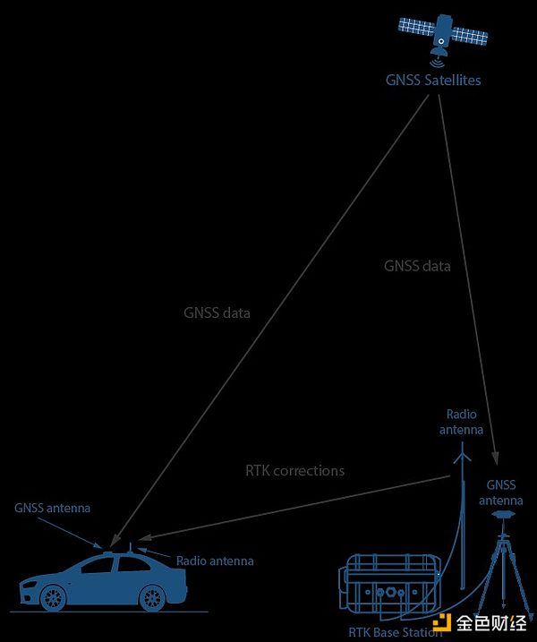
These methods have their own limitations, and no single system is foolproof. In the field of positioning methods, global navigation satellite system (GNSS) positioning using real-time dynamic (RTK) base stations for correction is considered one of the most reliable input methods.
TagAccurate GNSS positioning is inherently inaccurate due to atmospheric interference and multipath error, and the deviation can reach 5-10 meters. RTK solves this problem by using fixed base stations that compare satellite signals to known locations and transmit real-time correction data. This method can achieve centimeter-level accuracy, which is a key breakthrough in physical AI applications. Most large robots and automation companies integrate RTK into their systems, such as DJI for high-precision drones, John Deere for autonomous tractors, Tesla for autonomous cars, and Boston Power for Industrial inspection robot.
Image source: GNSS Store
One of the problems that RTK today is cost. The construction and maintenance of RTK base stations are capital-intensive, and a large amount of investment is required in hardware, site purchase, maintenance, etc. Traditional suppliers like Trimble, Hexagon and Topcon build these base stations themselves and charge customers thousands of dollars per tracked device, limiting access. Sex and deployment speed. The coverage is often concentrated in profitable areas, which makes it still impossible to obtain high-precision positioning services in some places.
Suppressing the cost structure through DePINWe have already elaborated in detail how token-incentive DePIN and owned by contributors structurally subvert the cost structure of global hardware-intensive networks. Geodnet, the world's largest precise positioning network, is using these principles to incentivize independent operators to install RTK base stations and provide correction data in exchange for token rewards.
By transferring the cost burden from a single operator to a distributed network, Geodnet is able to deploy production-grade RTK base stations at a fraction of the cost of traditional suppliers, specifically, to remove the construction of the network. Two maximum costs: land and labor. Therefore, compared with existing companies, Geodnet can expand coverage faster, ensure redundancy, and provide more reliable GNSS correction services.
The result is a global distributed network that naturally expands while ensuring the same service quality while reducing the usage price of end users.
Geodnet has been actively expanding since last year. The number of network base stations increased from 1,400 in November 2022 to 7,800 in June 2024. As of January 2025, it has more than 13,000 base stations in 4,377 cities and 142.
Image source: Dune Analytics
The network has reached a "critical scale" ”, its coverage is able to serve more than 60% of the potential GNSS correction market. It is worth noting that, the network has obtained this supply with extremely high capital efficiency, with only 11% of the total tokens being issued to contributors over the past three years.
Image source: Geodnet console
Geodnet is the DePIN mode in practice Typical examples of successful application in this article are not just theoretically feasible. Geodnet base stations not only have an order of magnitude lower purchase and deployment costs (i.e., consumer-grade equipment of $700 is compared to enterprise-grade RTK base stations of $12,000; more intensive deployments on consumer-grade networks can achieve a comparable coverage to enterprise-grade RTK base stations). Moreover, due to the savings of hardware deployment costs, the annual fee is also an order of magnitude lower. There is no doubt that Geodnet is the most scalable and cost-competitive positioning solution in the world today.
Currently, Geodnet's annualized chain revenue is about $3 million, which comes from Propeller, DroneDeploy, Quectel, and the United States. The enterprise-level service agreement signed by clients such as the Ministry of Agriculture (USDA) has grown the fastest in today's DePIN projects.
In our early conversations with Geodnet founder Mike Holden, we asked how he won some of the world’s most well-known self-driving cars , drone and agricultural robot customers. His answer is consistent: the core structural cost advantages brought by DePIN.
Turning PointIn the next decade, industries may deploy tens of millions of robots, changing the landscape in logistics, infrastructure and automation. The drone will conduct real-time inspections of power lines and pipelines. Self-driving cars will improve freight and taxi services. The warehouse will reduce its dependence on manpower through dedicated machines. Humanoid robots will appear in the family that help complete daily household chores.
None of these robots can run without reliable location data. Self-driving cars will require RTK enhanced GNSS when driving in dense urban areas where GPS cannot work alone. Drones need precise positioning to accurately land at charging stations. We believe that RTK positioning is not only a complement to other sensor modes such as LiDAR and RADAR, but also a crucial one.
Many robotics companies spend millions of dollars a year to purchase traditional GNSS correction services that are expensive, have limited coverage and are unstable in accuracy. We believe that Geodnet is now providing these customers with more cost-effective and higher quality products, and will benefit more customers in the future.
The artificial intelligence-driven robot boom is not a question of whether it will happen, but a question of when it will happen. Where are the robots? They are coming quickly. With Geodnet, we will know exactly where they are.